 It has been unseasonably warm, not only in East Texas, but a good majority of the Central Plains as well.
These were the high temperatures reported on Tuesday. While it may not be surprising to see San Antonio and Dallas hit 80°, it is hard to believe that cities such as Bismark, ND, and Minneapolis, MN topped out in the middle 70's.
A large ridge of high pressure is dominating the Plains, allowing the warm temperatures to stream northward all the way up to the Canadian border. It is also keeping major storm systems well away from us and keeping us dry.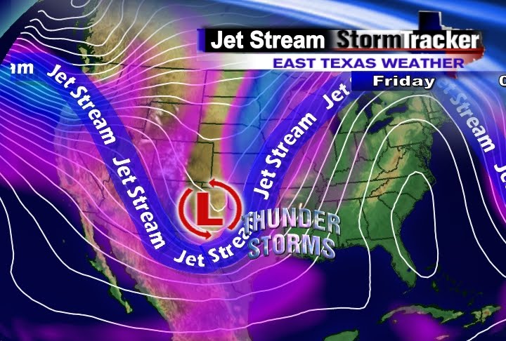
This weather pattern won't last, however. By Friday afternoon, the ridge of high pressure will slide off to the east, giving way to a very strong trough of low pressure to move into the Southern Plains.
This next storm system will spark off a complex of showers and thunderstorms in Central Texas late Friday afternoon. It is this complex of storms which will roll into the Texas Forest Country by Friday night.
Based on the timing of this next storm, it should move out by Saturday afternoon, giving way to sunshine and warm weather for Easter Sunday.
Tuesday, March 30, 2010
Warm and Windy Means Storms Easter Weekend
Friday, March 26, 2010
Past Decade Warmest on Record
In a report released on Thursday, the World Meteorological Organization (WMO) said that this past decade (2000-2010) was the warmest 10 year period since modern instrumental recording of temperatures began back in the 1850's.
The WMO also reported that 2009 ranked as the fifth warmest year on record.
In 2009, it was unseasonably warm in southern South America, Australia, and southern Asia. On the other hand, the United States, Canada, and Siberia experienced cooler than normal temperatures.
In the southern hemisphere, August and November broke previous temperature records.
For more information, go to http://www.wmo.int/pages/index_en.html
Friday, March 19, 2010
Ringing in Spring with a Winter Storm
 Old Man Winter is not quite done with East Texas, even though spring officially arrives at 12:32pm on Saturday afternoon. We will see all angles from this winter storm as it moves in on Saturday afternoon.
Wednesday, March 17, 2010
NOAA: Flood Threat Likely in the Next Few Weeks
 In a report just released by NOAA (National Oceanic and Atmospheric Administration), major flooding has begun and will continue to take place across the Northern Plains in the weeks and months ahead.
It's not so much from heavy rains, as much as it is the metling snowpack still on the ground.
"It's a terrible case of deja vu, but this time the flooding will likely be more widespread," says Jane Lubchenco, Ph.D., under secretary of commerce for oceans and atmosphere and NOAA administrator.
"As the spring thaw melts the snowpack, saturated and frozen ground in the Midwest will exacerbate the flooding of the flat terrain and feed rising rivers and streams," she says.
This flood threat across the northern half of the country is due to El Nino, the same weather pattern which has provided us in East Texas with a colder and wetter than normal winter season.
Jack Hayes, Ph.D and director of NOAA's National Weather Service, says the extent and severity of the flooding will depend on no major rain events.
"In the South and East, where an El Nino-driven winter was very wet and white, spring flooding is more of a possibiltiy than a certainty and will largely be dependent upon the severity and duration of additional precipitation and how fast existing snow cover melts," he says.
While we have seen 3 snow events in East Texas, they were short-lived and all the snow was melted within one to two days after the event.
In the meantime, residents in the upper Midwest will have to pray and hope that the major creeks, rivers, and streams, stay below flood stage. It would sure help if they could also avoid any heavy rainfall events in the near future.
**This article was written with excerpts from NOAA. If you'd like to read more on this topic, please visit their website at www.noaa.gov. **
Tuesday, March 16, 2010
Texas #1 for the Wrong Reason
A report just released by the Environmental Integrity Project (EIP) says that Texas is at the top of the list when it comes to Mercury pollution.
Mercury is a neurotoxin that can impair the development of infants and children if exposed to prolonged periods of this element.
The study showed that five out of the top 10 most polluting power plants, including the number one power plant mercury emitter, was found in Texas.
This report rates the power plants both in terms of sheer mercury pollution and mercury pollution per gigawatt hour.
This article is courtesy of: Texas News Advisory
A streaming audio replay of the news event will be available at www.environmentalintegrity.org
Monday, March 8, 2010
Unsettled Weather and Strong Storms
The first half of our work week will be rather unsettled with chances for rain and thunder each day through Wednesday.

 As a result of more moisture and higher instability, the Storm Predicition Center out of Norman, OK, has placed portions of East Texas, southern Arkansas, and much of Louisiana under a "Slight Risk" for severe thunderstorms during the day on Wednesday.
Tuesday, March 2, 2010
A Drought in Tornadoes
 In a report just released by NOAA, no tornadoes were reported in the entire month of February 2010. This is not just for the state of Texas, but the entire United States.
This is unprecedented, as we typically see more tornadoes in this time period, especially during an El Nino type of season like we are currently in.
It should be noted that the lack of tornadoes touching down in February will have no bearing on what the next few months will hold for the lower 48 in regards to the number and frequency of tornadoes. Past history has shown that if we go through a quiet month, sometimes the following months will be just as quiet or more active than normal. There is just no way to tell what this month or the rest of the subsequent months will bring in regards to the amount of Twisters we may see.
Nevertheless, it is interesting that in an El Nino season, which brings in more storms, there was not one single confirmed touchdown anywhere in the United States.

