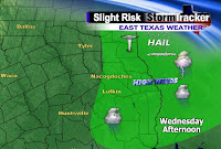
Of course, as is the case with any computer model, don't take it for its exact value. Storms could be in these locations as early as 3pm or as late as 7pm. This is just one particular model showing one solution.
While everyone has a chance to see a strong thunderstorm, not all locations will have an equal chance at getting wet. It does appear the best chances for seeing some thunder boomers will be along and east of Highway 59. That means if you live in Center, San Augustine, Hemphill, Zavalla, Jasper, and Newton, to name a few, then you will have the best chance to see rain. Areas around Palestine and Crockett will have a lower chance as the best lift and instability will be in our eastern counties.
The main threats with these storms will be damaging winds in excess of 50 mph, along with some small hail. While we can't rule out a tornado, I believe the strong winds with any of these storms will be our biggest threat.
Therefore, make sure you sign up for ThunderCall before it's too late. ThunderCall is a free service that will call your cell phone, landline, or any phone for that matter. It will be your first alert if a "Severe Thunderstorm" or "Tornado" warning is issued where you live.
You can also track the storms on our weather page with our live streaming radar and Interactive Radar.
After only dropping into the 60's the past several nights, low temperatures when you head out the door Thursday morning will be in the middle 40's. Chilly indeed. We could actually drop into the upper 30's briefly Friday morning, with high pressure settling in right on top of East Texas.
With plenty of sunshine, however, afternoon highs will still be in the 70's. Those 70's, by the way, will be about 10 degrees cooler than where we have been as of late. It will also drop us back to our normal values for this time of year.
Tuesday, April 6, 2010
Mid-Week Storms, Then Cooler
Posted by Brad Hlozek at 9:29 PM
Subscribe to:
Post Comments (Atom)


0 comments:
Post a Comment