Wednesday, April 28, 2010

Turning Unsettled, Stormy by Week's End

After seeing severe weather roll through East Texas last weekend, it has been nice to see some sunny and pleasant spring conditions this week.

However, all that is about to change as another spring storm will churn its way through the nations heartland by the end of the week.

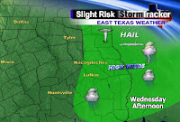
Since we are entering the peak of severe weather season, it looks like we could be in store for another round of active storms by Friday afternoon as our next storm system and cold front work into the Texas Forest Country.

The graphic on your left shows the areas most at risk for seeing some severe storms on Friday. The shading of green, which stretches from the eastern half of Texas to Louisiana and Arkansas, is where the best chance for severe weather to occur. The main threats Friday afternoon and Friday evening will be large hail, damaging winds (60 mph or greater), and even a few isolated tornadoes. With strong jet stream dynamics, there will be plenty of wind shear (changing of the wind speed and direction with height) in place to produce a few isolated tornadoes like we saw last week.

The one big difference between this incoming system versus the one we saw last week is forward speed.
The upper level winds and deep trough will not move much from Friday through Tuesday of next week.
As a result, we will have the chance for storms not just on Friday, but through the weekend and into early next week. This means there will be multiple chances for you to get wet during this five day period.
The good news is that this is the type of system that could give us some good, soaking rain showers to help put a dent in our 5 inch rainfall deficit.
The problem, however, could be the mutliple rounds of severe weather, due to all the moisture and dynamics in place.
So we will cross our fingers that your house gets some much needed rain, without receiving the hail and high winds.

Monday, April 26, 2010

Texas Twisters Hit Close to Home

It was a stormy end to last week as a widespread severe weather event unfolded across the Deep South on Friday and lasting through Saturday.


After the storms had passed, the National Weather Service out of Shreveport (www.nws.noaa.gov/shv) did storm surveys to determine whether or not the damage that was done from severe thunderstorms was from damaging winds or tornadoes.

As it turns out, they determined there were 4 EF0 tornadoes that touched down. Two of them occured on Friday night, while the other two touched down in the early morning hours on Saturday.

I have labeled the tornadoes so that you can follow the reports that were found from the Weather Service out of Shreveport. It should be noted that the order that I have labeled them is not from strength or intensity, but rather the time in which they occurred.
Tornado 1 (EF0): This was the first confirmed tornado that touched down at 7:34pm 5 miles to the south-southwest of Atlanta, TX. It traveled 5 miles with a tornado width of 50 yards before lifting around 7:41pm about one mile south of Atlanta. Its winds were estimated at around 65 mph.
Tornado 2 (EF0): The second tornado touched down just a few miles to the north of where the first one dissipated. This one touched down at approximately 7:41pm, just one mile west of Queen City, TX. This was the strongest of all the tornadoes that touched down in Northeast Texas as it traveled 18 miles on the ground and was 100 yards wide. This tornado then crossed the state line and into Arkansas before weakening around 8:10pm in Fouke, AR. The estimated winds were near 80 mph.
Tornado 3 (EF0): After a break in the action, a second disturbance moved in after midnight, dropping another tornado at 2:33am Saturday morning 5 miles northeast of Quitman, TX. This was a brief and weak tornado as it stayed on the ground for only 0.75 miles. Its width was 70 yards and had estimated winds of 65 mph.
Tornado 4 (EF0): The last tornado report was from a thunderstorm that dropped a tornado at 2:46 am, just 3 miles east of Mineola, TX. It traveled 2 miles and was 70 yards wide. Due to the fast movement of the twister, it lifted at 2:49am, about 5 miles east of Mineola. The wind speeds with this twister were around 75 mph.
**It should be noted that no deaths or serious injuries were reported. While many trees were uprooted and some small hay barns were destroyed, thankfully these twisters were very weak. Had they been EF2 or stronger, the damage and impacts would have been more significant and more deadly.**

Thursday, April 22, 2010

Severe Weather Outbreak Likely

For the past couple of months, Mother Nature has been rather tame in regards to spring thunderstorms. We are in the middle of severe weather season, and have yet to see any severe weather outbreaks.

That will be changing over the next 24 to 36 hours as a strong, spring storm churns through the Southern Plain states.


The Storm Predicition Center (SPC) out of Norman, OK, is the main government branch that issues Severe Thunderstorm and Tornado Watches. They also issue outlooks based on the risk for severe weather in a given part of the country. The graphic above shows a slight risk for severe thunderstorms on Friday as indicated by the shade of green. Notice, however, the shade of orange. That represents a moderate, or higher threat area for seeing severe thunderstorms on Friday afternoon and Friday night.

We have yet to see a moderate risk issued for our area so far this year. This means that the likelihood of seeing tornadoes, high winds, and hail will be higher than normal.


I have highlighted the main risk assessments we can expect as the storms roll in during the overnight hours. The risk for tornadoes and large hail is moderate, while the risk for damaging winds is high.


With the wind energy and all the dynamics in place, any storm that develops will rotate, possibly producing a tornado.


Here is one of our in house computer models. It suggests the main round of intense weather to roll in by daybreak on Saturday morning. Due to the fact many of us will be sleeping, you may be awakened by the rumbles of thunder and high winds.

Since these storms could roll in during the pre-dawn hours, it is very important you sign up for ThunderCall. ThunderCall is a free service we provide that alerts you when a Severe Thunderstorm or Tornado Warning is issued "Where You Live."

Since the storms could be moving in overnight, getting a phone call alerting you of severe weather in your area could be a life saver. I highly encourage you to take advantage of this service since many of you will be away from your television and radio.

I will keep you updated on the forecast and encourage you to tune in to your East Texas News for updates on our spring severe weather outbreak.


Tuesday, April 20, 2010

Dust off those Boots, it's time for the Rodeo!!

It is spring time and we are in late April which means one thing: time to get those boots and cowboy hats ready to go, because the Angelina Benefit Rodeo kicks off on Wednesday evening.

The Angelina Benefit Rodeo will take place at the Angelina County Expo Center and will run from Wednesday, April 21st through Saturday, April 24th.

Just like years past, this year will feature several great stunts and entertainers.

Opening night is Wednesday, and just like opening day when baseball or football season gets underway, it is the most anticipated moment of the entire event.

To double your pleasure, Wednesday night is not only opening night, but it is "KTRE Night" as well.

Me, along with some of my colleagues, will be out at the rodeo, partaking in some of the festivities and events.

We will be going live from the rodeo at 5 and 6 o'clock on the East Texas News.

Right now, the forecast for opening night looks great. We will see partly cloudy skies with warm conditions. Temperatures in the early evening will be in the middle 70's and then fall into the upper 60's to lower 70's by the late evening hours.

For a complete list of the events and festivities going on later this week at the rodeo, you can go to http://lufkinlions.com/rodeo/index.htm for all the information.

Friday, April 16, 2010

Bright Object in the Sky

You may have seen this story on the news over the past few days. It is the story of a bright object flying through the sky that was seen in several midwestern states.

Many wondered what it was. We came to found it was an asteroid which exploded in mid-air during a meteor shower. The explosion was so big, that it was the equivalent to 20 tons of TNT dynamite.


Picture Courtesy of: University
of Wisconsin-AOS/SSEC

It was that explosion that lit up the night sky across Iowa, Minnesota, Wisconsion, Missouri, and Illinois.

I often times receive phone calls from viewers who say they see interesting things in the night sky sometimes at night. If you are away from the cities and have complete darkness around, you can see these types of features from time to time.

They are not spaceships or aliens from another planet. More or less, it is usually something similar to what we saw in this story. Namely, a meteor shower racing fast at several thousand miles up in space.

For more on this story, you can go to http://www.spaceweather.com/.

Wednesday, April 14, 2010

Getting the Low Down on the Hoedown

It's that time once again. Time for the annual Lufkin Downtown Hoedown which is this Saturday, April 17th. It always takes place on the third Saturday in April and is one of my favorite events I look forward to each year.

From the arts and crafts, to the vendors, and live entertainment, there is something for everyone at this annual spring festival.

The Hoedown gets started at 10:30am with the parade that winds through downtown.

KTRE is a supporter and sponsor of this event each year and this year will be no different. Several of my colleagues and I will be situated along the "Big Slide." It is fun for the kids as they come sliding down a large blowup slide at a fast rate of speed.


Of course with every big event, the weather will play a large role on the turnout and success.

As of now, we are anticipating mostly cloudy skies with a 30% chance of some isolated showers. Don't let the rain chance scare you. The 30% chance of rain means there is a 3 in 10 chance that any community and neighborhood in the entire viewing area has a chance at receiving rain. Another way of looking at it is there is an 70% chance of no rain.

I should also point out that even if there is a shower, it should not last any longer than 15-20 minutes. By no means am I expecting a washout, just a few isolated showers here and there.

Of course, as we get closer, the forecast could change. Make sure to tune in to KTRE each weeknight at 5,6, and 10. I will have your latest updates and changes to the weather as the event draws nearer.

If you'd like a list of all the events, you can go to the Main Street Lufkin website at www.cityoflufkin.com/ms/hoedown.

Friday, April 9, 2010

Have You Been Sniffling and Sneezing? If So, You're Not Alone

The pollen count has been and will continue to remain high over the next few weeks as flowers and trees are in full bloom.

Considering the fact we are in the Texas Forest Country, we are surrounded by trees and lots of them.

The breezy conditions we have seen only irritate us allergy sufferers as it blows the pollen around, allowing it to accumulate on your vehicles. The wind is not the only thing that is leading to the higher than normal pollen count.

Warm temperatures also ignite the pollen count, making us sneeze even more.

At one point early in the week, we had around 2500 -3,000 particles per cubic meter. Think about that for a second. If you had a fish tank in 1x1x1 meter tank, that is how many particles of unhealthy air you would be consuming. In general, it only takes just 200-300 particles per cubic meter for a person with mild allergies to be affected.

This count is eight times more than what is needed to trigger an allergy sufferer. No wonder why you and I keep rubbing our nose.

There is some good news to report as of today. The pollen count has gone from extremely high down to medium, due in large part to the rain we saw on Wednesday night as storms rumbled through East Texas.

While the rain helped alleviate the pollen, it won't keep the levels down for too long. By this weekend, the windy, warm, and dry conditions will raise the pollen count back up into the high levels.

Tuesday, April 6, 2010

Mid-Week Storms, Then Cooler

A strong April cold front will be pushing through East Texas on Wednesday afternoon. This cold front will move in during the afternoon hours, providing us with a chance for showers and thunderstorms. Our Microcast computer model suggests that the storms will be east of Highway 59 by 5pm, stretching from Jasper to Newton and back to the southwest towards Woodville.


Of course, as is the case with any computer model, don't take it for its exact value. Storms could be in these locations as early as 3pm or as late as 7pm. This is just one particular model showing one solution.

While everyone has a chance to see a strong thunderstorm, not all locations will have an equal chance at getting wet. It does appear the best chances for seeing some thunder boomers will be along and east of Highway 59. That means if you live in Center, San Augustine, Hemphill, Zavalla, Jasper, and Newton, to name a few, then you will have the best chance to see rain. Areas around Palestine and Crockett will have a lower chance as the best lift and instability will be in our eastern counties.
Due to the fact we are so warm and humid out ahead of a strong, spring storm, we have a slight risk of seeing some of those storms on Wednesday turn severe.

The main threats with these storms will be damaging winds in excess of 50 mph, along with some small hail. While we can't rule out a tornado, I believe the strong winds with any of these storms will be our biggest threat.

Therefore, make sure you sign up for ThunderCall before it's too late. ThunderCall is a free service that will call your cell phone, landline, or any phone for that matter. It will be your first alert if a "Severe Thunderstorm" or "Tornado" warning is issued where you live.

You can also track the storms on our weather page with our live streaming radar and Interactive Radar.

After the storms move out, noticeably cooler air will be blowing in. You will notice the biggest difference behind the front in the form of our overnight low temperatures.

After only dropping into the 60's the past several nights, low temperatures when you head out the door Thursday morning will be in the middle 40's. Chilly indeed. We could actually drop into the upper 30's briefly Friday morning, with high pressure settling in right on top of East Texas.

With plenty of sunshine, however, afternoon highs will still be in the 70's. Those 70's, by the way, will be about 10 degrees cooler than where we have been as of late. It will also drop us back to our normal values for this time of year.

Thursday, April 1, 2010

It Changed The Way Weather Was Forecasted

Weather forecasting has come a long way from where it first began. We can now forecast several days to even weeks in advance thanks to all the satellites and super computers.

Before we had satellites, however, no one had good forecasts, and on many occasions, no one would know if there was a tropical storm or hurricane in the Gulf.


Times have changed and today marks the 50th Anniversary of the first satellite to ever go into orbit in outer space.

This satellite is known as TIROS-1 (Television Infrared Observation Satellite). It was launched into outer space from Cape Canaveral, FL, in 1960. It was this TIROS-1 that forever changed the way weather was seen and forecasted.

"Since TIROS-1, meteorologists have far greater information about severe weather and can issue more accurate forecasts and warnings that save lives and protect property," said Jane Lubchenco, P.h.D. and NOAA administrator.

"TIROS-1 started the satellite observations and interagency collaborations that produced vast improvements in weather forecasts," said NASA Administrator Charles F. Bolden, Jr. "It also laid the foundation for our current global view of Earth that underlies all of climate research and the field of Earth system science."

After the TIROS spacecrafts were launched, the GOES (Geostationary Operational Environmental Satellite) was launched in 1975. Its ability to orbit in synce with the rotation of the Earth enhanced NOAA's forecasting.

The advances in forecasting has helped us in identifying weather patterns and storm systems across the globe.

The satellites have also enhanced the climate research and the ability to detect sea surface temperatures. It is this capability that allows climatologists to monitor areas of severe drought and predict the onset of climate pattern changes that deal with El Nino and La Nina.

So the next time you see a satellite and radar loop, remember that the imagery is coming from satellites several hundred miles in outer space.

After all, if it was not for satellites, we would not be able to predict the weather in an accurate or timely manner.

For the complete story, you can go to http://www.noaa.gov/. You can also check out NOAA'S Satellite and Information Service at http://www.nesdis.noaa.gov/.