Sunday, November 20, 2011

Getting Turkey Week Off to a Wet Start

Just like clockwork, another storm system out west will be moving into the Southern Plain states late Monday and into early Tuesday, giving Deep East Texas another good chance for beneficial rainfall.

Just like the past couple of weeks, there is a "slight" risk for severe weather. That means some of the embedded thunderstorms within the heavier downpours could contain small hail and damaging winds. At this time, the severe threat is rather low due to the timing of this system.


(Image courtesy of: Hydrometeorological Prediction Center)


The image above was taken from the Hydrometeorological Prediction Center (HPC). This is the rainfall potential from Monday evening at 6pm through Tuesday evening at 6pm. Notice that the heaviest rainfall will stretch from Oklahoma to Arkansas and into southern Missouri.

The shading of blue painted on the map, represents 0.50"-1.0" of rain on average for the Pineywoods. It should be noted that some areas may receive higher rainfall amounts, but overall, it looks as if Mother Nature will send her blessings on us right before the Thanksgiving holiday.

Timing is Perfect

The timing with this storm system will work in our favor in regards to Thanksgiving travel this week. The storm will exit stage right on Tuesday afternoon, meaning Wednesday will be a nice day for all the travelers hitting the roadways.


Thanksgiving Day is also looking nice, with mostly clear skies and cooler temperatures.


But as we have seen this month, nothing stays the same for too long. Another quick moving low pressure system will bring back warmer temperatures and another chance for rain by Friday and next weekend.
Thursday, November 17, 2011

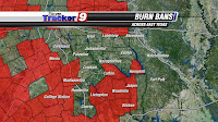
More Burn Bans Lifted, But We Need More Rain

Several counties have lifted their burn bans over the past week, mainly as a result of recent weekly rainfall, and the added pressure from citizens who rely on burning their own trash.

Of our main 13 counties we serve in the KTRE viewing area, 8 of them have now lifted their burn bans, with more likely to follow suit in the days ahead.

Even though burn bans have been lifted, that is not necessarily a sign of an improvement in the drought situation.

During the month of November, we typically average 0.15" of rain per day. That means that in a week's time span, we should receive over an inch of rain just to stay on par with average rainfall for the month.

So far this month, we have had two heavy rain events that have fallen on back to back Tuesdays. While the rain is much welcome, we need even more just to put a dent in the drought. Keep in mind that many of our weather watchers have been reporting 0.40-0.75" of rain with these storm systems, with just a few areas reporting in over an inch.

If you do the math, the drought has not improved one bit. What we need is 2-3 days of steady, persistent rain per week in order to cut into the 17" deficit we now have for the year.

So while the weekly rainfall is nice, it would be even better if we had multiple days of rain, rather than just one day per week.

Thursday, November 10, 2011

National Weather Service Confirms Two Tornado Touchdowns

National Weather Service meteorologists out of Shreveport surveyed the damage from Tuesday's severe thunderstorms on Wednesday and concluded that two tornadoes touched down in Deep East Texas.

The first twister touched down at 2:02pm, five miles southwest of Mount Enterprise in northern Nacogdoches county. It moved northeast and caused tree damage along FM 950 and FM 3272 before lifting just west of Highway 259. According to the National Weather Service, the tornado lifted just west of Highway 259 before touching down a second time along FM 3198 near FM 3191. As the tornado continued its second track, it ended up causing widespread tree damage near Highway 84 and FM 3191 before lifting at around 2:26pm.


This first tornado was rated an EF1, with estimated wind speeds of 90 mph. It had a maximum width of 150 yards and had a path length of 12 miles.


(Brad Hlozek cuts in to programming to keep viewers informed on tornado warnings on Tuesday afternoon.)

About an hour later, another tornado touched down in the same general vicinity as the first one. This time, it occurred at 3:34pm, three miles west of Mount Enterprise, just north of Highway 84. This tornado uprooted trees along its journey, before dissipating at 3:43pm just west of the intersection of FM 95 and Highway 315.

Unlike the first twister, this second one was weaker and rated an EF0, with estimated winds of 80 mph. It had a maximum width of 70 yards and a path length of 6 miles.

The best news to report out of these two tornado touchdowns on Tuesday was that there were no injuries or fatalities, as they stayed over mainly rural areas.

Monday, November 7, 2011

Heavy Rain, Strong Storms Likely Tomorrow

Another storm system and cold front is headed for East Texas tomorrow night. However, unlike the past few fronts, this cold front and storm system will be more potent, meaning the threat for heavy rain and severe weather will be possible.


While we may not see much rain for the first half of your Tuesday, that will change by the late afternoon and early evening hours as a trough of low pressure moves through the Pineywoods.

As you can see by our in house Microcast computer model, a squall line (fancy term for strong line of storms) is expected to rumble through Deep East Texas by the late afternoon or early evening hours. It is along this line of storms where there will be a threat for damaging winds ( > 50 mph), small hail, and frequent cloud-to-ground lightning strikes.


It has been quite a while since we had a threat for severe weather. Therefore, make sure to heed warnings if your county gets placed under one tomorrow.


Now to the Bright Side

It should be noted that the severe weather threat is low; what is more likely and beneficial for us all, is the rainfall potential.

Our Microcast computer model shows rainfall will vary from place to place; however, average rainfall amounts will range from 0.25" to as much as an inch in spots.

The return of moisture to the area will aid in rainfall potential with this particular storm system, as it helps increase the instability across the region.

Our rain chances will taper off quickly from west to east Tuesday night as the cold front pushes through Deep East Texas. The front will clear out the skies and usher in some cooler weather for the remainder of the week.


Friday, November 4, 2011

Solar Activity Means More Northern Lights

The sun is displaying more sunspots and will be very active over the next few weeks. This is due to the CME (coronal mass ejection) that takes place along the surface of the sun.


(Photo courtesy of NASA from Sep. 2011)


Due to these solar flares, Northern Lights will be visible across the night sky over the next couple of weeks.


According to Space Weather, the sunspot, named AR1339, is not yet directly facing Earth but it will be turning toward our planet in the days ahead.


The sunspot group has already caused a large CME, but it was not directed at Earth. As the sunspots travel across the sun's face in the next few weeks, the coronal mass ejections could be directed at Earth causing aurora displays.


If your wandering eyes happen to catch these Northern Lights, feel free to snap a picture and submit it to sendit@ktre.com. That will upload the picture to our "See It, Snap It, Send It" photo gallery at ktre.com.