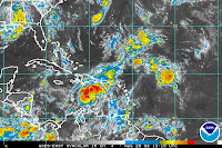
 As Fay brings heavy rain and tornadoes to parts of the southeast, our next tropical features is ready to become Tropical Storm Gustav. The graphic to your left shows this storm in the Caribbean, just south of Hispaniola. It is moving to the northwest at about 15 mph. The environment around soon to be Gustav is very conducive to tropical development, with warm waters and low wind shear. As for the forecast, this one will be another difficult one to track. Some models take it north into Florida, close to the same path Fay took. Other models send the storm towards the Yucatan and possibly into the Gulf of Mexico. It is way too early to tell where this storm will go but I want you to be aware and stay tuned to KTRE for the latest.
Monday, August 25, 2008
The Next Tropical Trouble
Posted by Conley Isom at 9:10 AM
Subscribe to:
Post Comments (Atom)


0 comments:
Post a Comment